


I was privileged to attend a meeting at the Okaloosa County Emergency Management facility in Niceville last week and wanted to share some of the information discussed during the presentation given by state and local leaders. They are already planning for the next storm so we should too!
Evacuations and storm surge
I know this past hurricane season for the panhandle was a series of close misses but Walton County, including 30A and the coast in Santa Rosa Beach, did have its first voluntary evacuation order in years. Most evacuations are because of storm surge, not wind. 88% of deaths in storms since 1963 are related to water: 49% from storm surge, rain accounts for 27%, and surf/offshore are the remaining 12%.
Storm surge is the sudden rush of water driven by wind. Destin is more elevated than you might think, the highest part of the peninsula is actually the beachfront so it takes quite a surge to flood the entire area. Storm surge doesn’t take into account the tide, so the actual water height could be a foot or two higher. Add breaking waves to the top of that and driven water during a storm could end up several feet higher than the forecasted storm surge and go further inland than you expected.
Many homes in our area, especially those in the COBRA zone that spans from Kelly Plantation to the county line, are elevated above the natural grade. Flood insurance is notoriously difficult to get in these areas (see our article here about flood insurance and preparation) so increasing your elevation is one of the best things to do. Even adding a few feet can be the difference in losing it all or being completely dry. 6 inches of water is enough to lose control of a car, a foot will float many vehicles, two feet will float most vehicles, and 3 feet is considered life threatening.
Category 4 is worse than Category 2, right?
The category is determined purely by wind speed, which would be like selling cars based only on their horsepower. We all know there's a lot more to it than that but get hung up on this because it's easy. Here's an interesting example of why the category doesn’t necessarily tell the whole story:
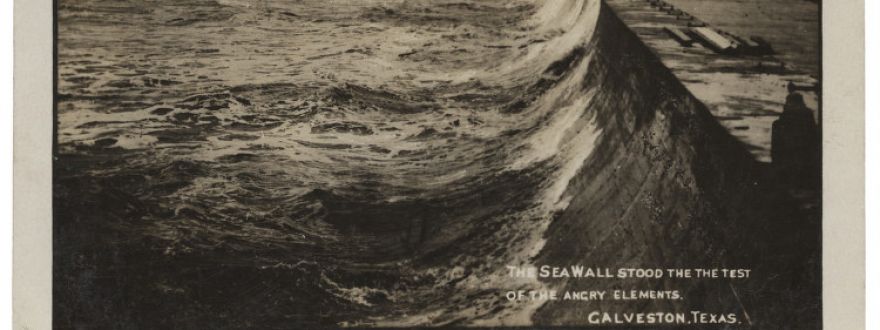
Hurricane Ike (Sep 2008) skirted the Florida Keys before making landfall near Galveston Texas as a Category 2 storm. Cat 2, no big deal, right? Evacuations were ordered, refineries closed, but nearly 50,000 people didn’t evacuate. Residents felt safe because Galveston has a 12ft seawall, built over a hundred years ago out of concrete which has worked well protecting them in the past. It would certainly make me feel safer if I lived there. For comparison, much of Fort Walton Beach, Shalimar, Niceville, and Bluewater Bay are around 12-15 feet above sea level.
However, the elevation in Galveston is about 7 feet, which is about the same as Mary Esther. So if water breached the wall, the whole town would be flooded. Long story short, Galveston wasn't safe- the storm surge was nearly 17 feet, eclipsing the seawall and putting 5 feet of water through the city. If our town had that much surge, the areas mentioned before could have waves at their front doors, plus Valparaiso, Freeport (not Hammock Bay), and everything north of Hwy 98 from Kelly Plantation past the 331 bridge. Speaking of bridges, every bridge on 30A would probably be underwater.
Now compare this to Hurricane Charley (Aug 2004), one of the strongest hurricanes to ever strike the US. As a Category 4 storm, it had winds peaking at 150mph. This hurricane is memorable because it changed from a Cat 2 to a Cat 4 only two hours before making landfall just south of Tampa. The largest storm surge caused by Charley was about 10 feet, 70 miles south of the eye near Naples, but the surge near the center of the storm was much less. If a storm like this hit out area, the 5-7 foot storm surge would spare most of the areas I listed above. It probably wouldn’t breach the coast but could still flood areas within a hundred feet or so from the bay, especially Santa Rosa Beach.
Be Prepared
This meeting in Niceville was an effort to coordinate between the different agencies that assist before, during, and after a storm and I have great faith in their abilities. We have some of the best people available working for our safety and looking far ahead so we don’t have to. Take some time before this hurricane season starts to assess your owns risks, maybe with your family, home, or business. Make plans to best keep your people safe and think ahead so that no storm will take away anything that can't be replaced. Many property insurance policies exclude wind and flood, so check yours and call Norton Insurance for a Wind or Flood quote today!
The views expressed here are the opinion of the author and do not attempt to make any recommendation for insurance coverage. Eligibility is determined by the insurance carrier and not all applicants will qualify. Please contact your licensed insurance agent regarding your area's coverage and eligibility.